Seymour Narrows is a long, slender, dangerous stretch of water north of Campbell River, B.C.. Like many sites in this part of the world, vast amounts of water are forced by ocean tides through narrow passages, which creates high water currents (15 knots at times) and dangerous conditions — whirlpools, overfalls, and other boat-busting conditions.
Explorer George Vancouver described Seymour Narrows as "one of the vilest stretches of water in the world." The rapids have claimed over a hundred lives and is regarded by many sailors as the worst hazard to marine navigation on the British Columbia coast.
This stretch of water was even worse before 1958. Before that year, a dangerous pinnacle named "Ripple Rock" reached within nine feet of the surface of the narrows, creating dangerous whirlpools as well as gouging out the bottoms of many passing vessels and sending them to the bottom. But in 1958, a carefully prepared explosion of over 1000 tons of explosives blasted Ripple Rock away, making the narrows safer.
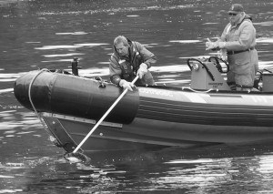
Coast Guard recovers body
near Seymour Narrows
But the new, safer Seymour Narrows is still a dangerous place. At times of high current, whirlpools form that can draw a boat — or a man — to the bottom. This journey marked my fifth time through the narrows. When I first made the passage, I used my tide program
JTides
to predict times of near-zero currents (so-called "slack water"). Since then I've realized that currents less than about five knots are manageable if there is no contrary wind (just my opinion — vessels differ, as do skippers). This is a case where a tide/current prediction computer program capable of providing minute-to-minute predictions has it all over a printed table that only shows current peak times and slack times.
As I completed my passage through the narrows, I heard a fisherman in a small boat calling the Canadian Coast Guard on the emergency marine channel. It seems he could see a body floating in the water. I was nearby so I diverted to the site and provided the Coast Guard with a GPS position. This episode only served to remind me how dangerous this place can be.
At the time of recovery no one seemed to know who the victim was. About an hour later, the Coast Guard made a general announcement on the emergency marine channel, asking all vessels in the area to verify that their crews were all present and accounted for. But I didn't hear the conclusion of this story, because I sailed on.
On the general topic of wind and current, I want to describe a special, rather risky water condition that arises in places like Seymour Narrows. It is described by sailors in everyday language as "opposing wind and current." In this condition, current flows in one direction and wind blows in the opposite direction. This can result in dangerous wave heights and very rough conditions, for a reason that is neither obvious nor commonly understood by sailors.
Many sailors believe this condition results simply from adding wind velocity to current velocity, since they are in opposition. If this were true, it would mean a wind of twenty knots and an opposing current of five knots would produce wave heights typical of a wind velocity of 25 knots and no current. But in fact, in many cases wave heights are much higher than this simple addition of velocities would predict.
The reason? Water current passing across irregularities on the bottom (or being deflected by the sides of a narrow channel) can create ripples in the surface of the water — anyone who has watched water flowing in a stream has seen this effect. But the opposing wind prevents the waves created in this way, and the energy they represent, from moving away from the point of their creation, and this confinement effect causes the waves to become much larger. To say it another way, the wind concentrates and confines wave energy in a way that builds huge waves out of what might have been small ripples if the wind was not blowing. Technically, it is a positive feedback system in which wind energy is expended to build large waves out of small ones, and in some cases, the result can be waves of stupendous heights that appear not to be moving across the water very much if at all. These abnormally large waves are called "standing waves" or "solitons."
On a couple of occasions on this voyage, I found myself surfing down the face of very large waves in conditions exactly as described — relatively shallow waters, opposing wind and current. I could have planned my passages more carefully and avoided this particular mix of conditions, but I rarely plan passages that carefully.
On the open ocean, this "opposing wind and current" effect is thought to produce what are called "rogue waves," huge waves 100 feet tall or more, that have been known to destroy ships. In this case, a series of storm-driven waves collide with an opposing current, and the storm waves simply pile up higher and higher just as described above, but on a much larger scale. This effect damages or destroys two to three tankers each year off the east coast of Africa.
One morning I departed Graves Harbor just north of Cape Spencer in southeast Alaska and proceeded across Cross Sound. I failed to plan for the strong ebb current and brisk westerly wind and the effect this combination would have over a patch of relatively shallow water at about 58° 10' N, 136° 38' W. As I approached this shallow patch, the wave heights quickly grew, and I once again kicked myself for not carefully evaluating the conditions before entering a channel where strong currents sometimes flow.
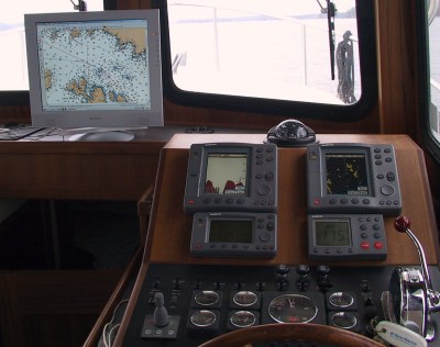
On my original southerly heading, the boat started to roll rather severely, such that I had to put a plug in the sink to keep water from squirting out on each roll. I decided things were getting dangerous, also I saw on my real-time chart display (see photo at right, flat-panel display at upper left) that I had allowed myself to get into a shallow area, so I decided to head east, toward Elfin Cove, where I knew there were sheltered waters. But this turned out the be a very bad idea — because my new heading was directly downwind, the boat commenced surfing down the face of each new wave, at high speed, and I had to steer the boat agressively to prevent a broach. After a few minutes of that I returned to my original southerly course and tolerated the rolls. To put it another way, I realized the cure was worse than the disease.
To digress for a moment, this event (and some others like it) show the limitations of a hull design like mine in certain conditions. A more traditional, not to say dumpy, boat design, with a deeper keel, would not behave that way in those conditions. It would simply bob around, resisting the efforts of the waves to make the boat broach and then, had conditions been more severe, possibly even roll over. In fact, having owned a couple of ocean sailboats, I know this is true. They may not get anywhere very fast, but they do get there eventually.
End of digression. After resuming my southerly course, I took another glance at my chart display and saw the shallow patch was not particularly large, and I would likely be beyond it in a matter of minutes. This turned out to be correct — as soon as the depth increased, the severity of the effect dissipated.
This was just one of about five occasions on this trip in which I ended up surfing my boat down very steep waves (or beating against them if traveling upwind), in similar conditions: shallow water, strong current, strong opposing winds. And each time I could have planned the passage more carefully.


 Share This Page